

The Global Drought Mosaic (GDM) is developed and maintained by the Integrated Drought Management Programme (IDMP) and aims to provide an overview of global drought conditions.
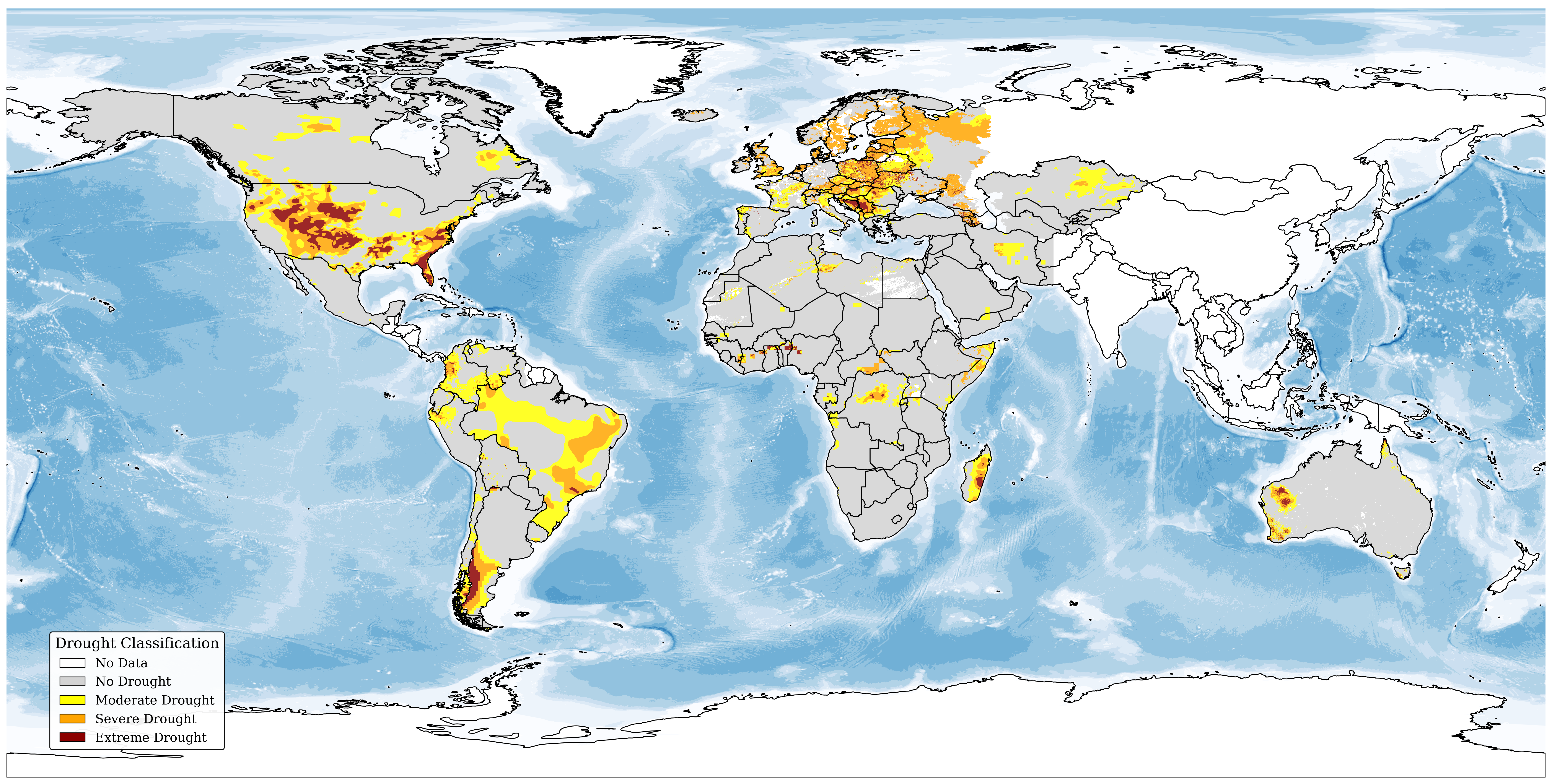
Global Drought Mosaic (GDM), May 2026
The GDM uses a bottom-up approach, integrating data from national and regional monitoring systems to preserve region-specific characteristics and regional relevance while improving global consistency and accessibility. To account for the range of drought indicators provided by partners, data are qualitatively classified into four common categories: no drought, moderate, severe, and extreme drought.
The GDM is not intended to serve as an operational drought monitoring tool. Operational drought monitoring is provided by national and regional systems that are tailored to local climatic conditions, user needs, and decision-making contexts. The GDM neither aims nor can replace these systems. Instead, it provides a pragmatic global overview of drought conditions through the qualitative harmonization of existing regional and national products.
A detailed description of the harmonization methodology, including the reclassification approach applied to each contributing national and regional monitoring product, is available in the accompanying methodology document.
The GDM is produced four times per year for the months of February, May, August, and November. Because some partner datasets are only available several weeks after the reporting month, publication typically takes place around one month later, once all available data have been compiled and harmonized.
The designations employed and the presentation of material herein do not imply the expression of any opinion whatsoever on the part of the Secretariats of WMO or the United Nations concerning the legal status of any country, area or territory, or of its authorities, or concerning the delimitation of its borders. The depiction and use of boundaries, geographic names and related data on maps and in lists, tables, documents and databases herein are not warranted to be error-free and do not imply official endorsement or acceptance by WMO or the United Nation.
If a region lacks coverage, this does not necessarily mean no monitoring system exists. The map is a living resource, continuously updated as new information becomes available.
Contributors and Coverage:
The GDM is only possible due to continuous support of partner organisations and entities. Below is a visualisation of the data currently included on a regular basis from partners (Note that on the monthly representation some data might be added with slight delays, if data was not available at the time of publication). Should you notice any error, please contact us at droughtmanagement@wmo.int .
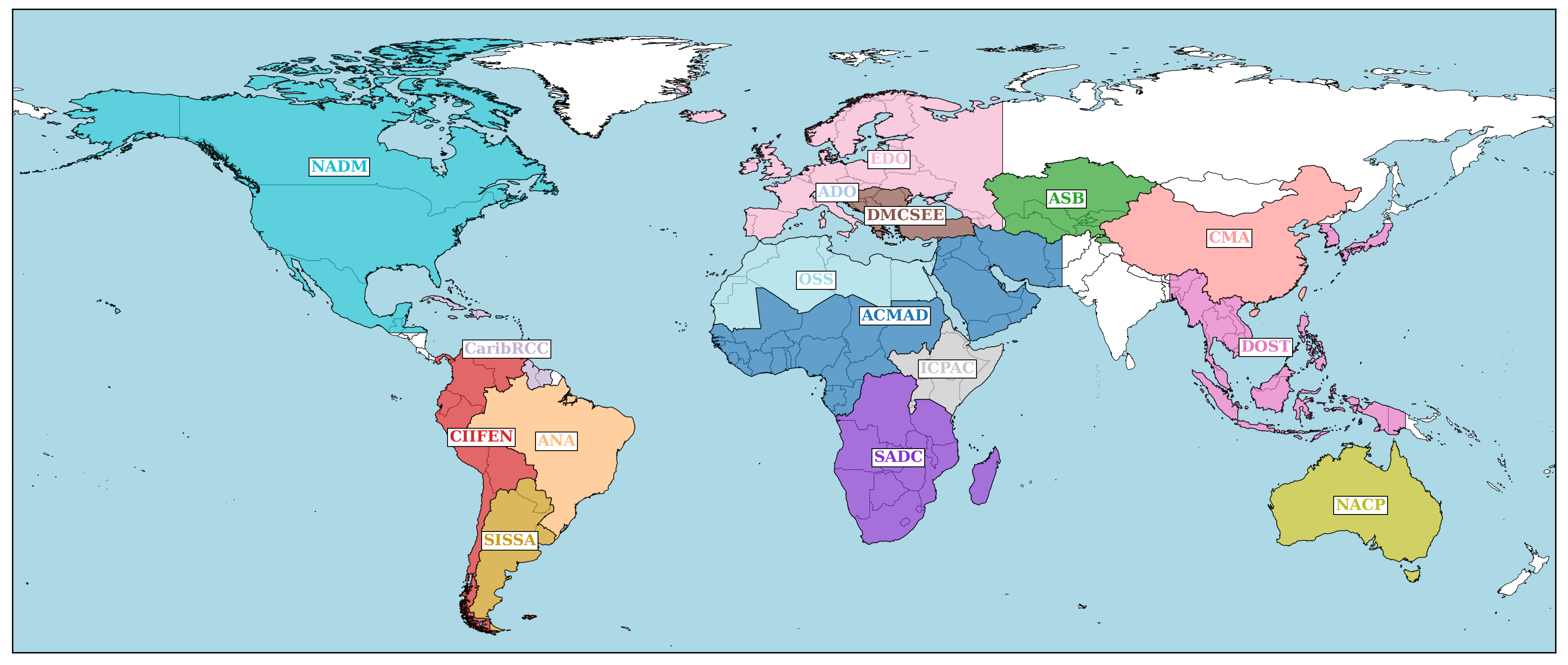
Coverage of Global Drought Mosaic
- NADM: North American Drought Monitor hosted by National Centers for Environmental Information (NCEI) (Link to Website)
- CaribRCC: SPI Monitor by the Caribbean Regional Climate Centre at Caribbean Institute for Meteorology & Hydrology (CIMH) (Link to Website)
- CIIFEN: Boletín de Sequías by Regional Climate Center for Western South America (CIIFEN) (Link to Website)
- ANA: Monitor de Secas by Agência Nacional de Águas e Saneamento Básico (ANA) (Link to Website)
- SISSA: Índices de sequía en estaciones meteorológicas by Sistema de Informacion Sobre Sequias para el Sur de Sudamerica (SISSA) (Link to Website)
- SADC: Climate Monitoring by Southern African Development Community Climate Services Centre (Link to Website)
- ICPAC: East African Drought Watch by ICPAC (Link to Website)
- ACMAD: Africa Drought Monitoring and Advisory by Africa Centre of Metrological Applications for Development (ACMAD) (Link to Website)
- OSS: Crop Monitoring and Early Warning in North-Africa by Sahara and Sahel Observatory (OSS) (Link to Website). Shown data derived from European Drought Observatory, https://drought.emergency.copernicus.eu (C) European Commission – JRC, 2012 – 2025
- DMSCEE: Drought Monitoring Bulletins by Drought Management Centre for Southeastern Europe (DMCSEE) (Link to Website)
- ADO: Alpine Drought Observatory by EURAC Research with Slovenian Environment Agency & Central Institution for Meteorology and Geodynamics (Link to Website )
- EDO: Copernicus European Drought Observatory (EDO) by European Commission – Joint Research Centre (Link to Website)
- ASB: Drought Map – Aral Sea Basin by Green Central Asia, GIZ, Martin Luther University Halle, Germany (Link to Website)
- CMA: 中国旱涝监测 by Bejing Climate Centre (CMA) (Link to Website )
- DOST: South East Asia Climate Monitoring Project by The Climate Monitoring and Prediction Section of DOST-PAGASA (Philippine Atmospheric, Geophysical And Astronomical Services Administration) (Link to Website )
- NACP: Drought Monitor by Northern Australia Climate Program (The University of Southern Queensland (UniSQ), Bureau of Meteorology (BoM), the UK Met Office, State Departments of Agriculture in Queensland (DAF), Northern Territory (DITT), and Western Australia (DPIRD) and four Natural Resource Management groups.) (Link to Website)